URBUS
Strategic Thinking for Tomorrow's Cities
Shaping Cities /
Unlocking Potential
Strategic Consulting for Urban Development, Housing and Sustainable Growth
We work at the intersection of data, design, and community to reshape the built environment. From small neighbourhoods to major metropolitan zones, URBUS brings a rigorous, human-centred approach to every challenge — understanding each city's unique spatial character, social dynamics, and long-range potential before proposing a single solution.
URBUS is a strategic urban consulting firm with offices in London and Athens, focused on shaping cities through evidence-based planning and design. It works at the intersection of data, design, and community to reshape the built environment, bringing a rigorous, human-centred approach to challenges ranging from small neighbourhoods to major metropolitan zones.
What we do spans eight core service areas: urban strategy, mobility planning, data analysis, community engagement, smart cities, sustainable development, transit systems, and public space design.
In short, URBUS is a boutique urban consultancy that combines strategic thinking, spatial analysis, and community engagement to help cities become more liveable, sustainable, and equitable
We believe cities are the defining challenge of our generation — complex systems where policy, culture, infrastructure, and daily life must align to create places worth living in.

We believe cities are the defining challenge of our generation — complex systems where policy, culture, infrastructure, and daily life must align to create places worth living in.
People
The heart and the brain of the office is their people
Konstantinos Labrinopoulos
Principal Architect + Urban Thinker
Education
M.Arch III, SCI-Arc, Los Angeles
M.Arch, National Technical University of Athens (NTUA)
Experience
Konstantinos brings twenty years of experience translating complex urban challenges into built outcomes. He has led award-winning projects across Greece, the UK, and the Middle East, and is a visiting lecturer specialising in urban form and strategic master-planning.
Socrates Zachos
Urban Strategist
Education
PhD Computational Design, IaaC, Barcelona
MArch Advanced Design, UCL Bartlett, London
Experience
Socrates specialises in long-range urban strategy, translating policy ambitions into actionable master plans. He has advised regional governments in Southern Europe on growth frameworks, housing strategies, and data-driven spatial analysis.
Stefanos Katsolis
Transportation Specialist
Education
MSc Transport Planning, TU Delft
BEng Civil Engineering, University of Patras
Experience
Stefanos focuses on sustainable mobility — from bus rapid transit corridors to cycling infrastructure and pedestrian-priority streets. He combines traffic modelling with community insight to design systems that people actually use.
Our Methodology
Our methodology combines rigorous research, community engagement and cutting-edge technology to deliver transformative urban solutions.
01
Analyze
We begin with a deep reading of the city — examining urban data, demographics, infrastructure networks, land use patterns, and economic flows. Every recommendation is grounded in evidence drawn from the specific context of each place.
02
Engage
Community-centred process involving all stakeholders — residents, local organisations, businesses, and municipal authorities. We create genuine dialogue, not consultation theatre. Every voice shapes the outcome.
03
Design
Integrated solutions balancing economic viability, environmental sustainability, and social equity. We design systems, spaces, and policies — not just buildings — to address the full complexity of urban life.
04
Implement
Phased rollout with continuous monitoring and optimisation. We stay engaged through delivery, adjusting in response to real-world feedback and changing conditions to ensure long-term impact.
A Deeper Insight
URBUS DNA
Every city is shaped by three interconnected systems: its Geometry — the spatial logic of streets, blocks and buildings; its Culture — the history, memory and social life embedded in its fabric; and its Ecology — the natural systems of climate, water and green infrastructure. Understanding how these three forces interact is the foundation of every project URBUS undertakes.
"When these three align, cities become extraordinary places to live."
URBUS Quality Index
The Human Scale Principle
Urban Morphology
Culture Density
Climate
What We Do
Services
URBUS develops long-range strategic frameworks that guide cities and regions toward more equitable, resilient, and liveable futures. We combine quantitative analysis with deep local knowledge to produce strategies that are both ambitious and achievable.
Urban strategy is not master planning — it is the long-range thinking that makes master planning possible. Before drawing a single line, URBUS maps the forces shaping a city: demographic shifts, economic pressures, mobility systems, cultural identity, and environmental vulnerabilities. Our strategies set priorities, define spatial frameworks, and align stakeholders around a shared vision of what a city can become.
Urban Strategy
Defining long-range goals and frameworks for how cities and regions should develop — setting the priorities, principles, and policies that shape every subsequent planning decision, grounded in evidence, community input, and each city's unique context.
Smart Cities
Using digital technology, sensor networks, and real-time data to improve the efficiency, sustainability, and quality of urban services — approached critically, prioritising solutions that are genuinely useful to citizens and that increase equity, not technologies deployed for their own sake.
Mobility Planning
The strategic design of how people and goods move within and between urban areas — going beyond transport infrastructure to address behaviour, land use, public health, and equity, ensuring every person has access to the places that matter to them.
Sustainable Development
Development that balances environmental resilience, social equity, and economic viability together — designing for genuine long-term sustainability rather than short-term green credentials or certification box-ticking.
Data Analysis
Using quantitative and spatial data — demographics, mobility flows, land use patterns, and environmental conditions — to understand how cities function and evaluate the impact of planning decisions before they are made, producing recommendations that are evidence-based rather than assumption-based.
Transit Systems
Designing networks of buses, trams, metro lines, ferries, and rail services that are legible, frequent, reliable, and genuinely competitive with the private car — reducing car dependence and connecting communities to economic opportunities.
Community Engagement
Structured, transparent processes for involving residents, businesses, and other stakeholders in planning decisions — creating genuine influence over outcomes, building trust between communities and institutions, and producing plans more likely to be implemented and maintained.
Public Space Design
Designing streets, squares, parks, waterfronts, and other shared spaces that are safe, inclusive, beautiful, and actively used — treating public space as the most important output of urban planning and the physical stage on which civic life is performed.
Case Study 01
Seaside Towns & Islands
Coastal and island settlements face a unique combination of pressures — seasonal tourism economies, climate vulnerability, ageing infrastructure, and outmigration. URBUS develops integrated strategies that strengthen year-round economic resilience while protecting the environmental and cultural assets that make these places distinctive.
Case Study 02
Neighbourhoods
At the neighbourhood scale, URBUS focuses on the interplay between housing, public space, mobility, and local economy. We work with residents and institutions to develop strategies that address displacement risk, improve connectivity, and build community capital over the long term.
Case Study 03
Islands
Island territories present distinct planning challenges — limited land, fragile ecosystems, and dependence on external supply chains. Our approach integrates spatial planning, infrastructure strategy, and economic development to create self-sufficient, sustainable island communities.
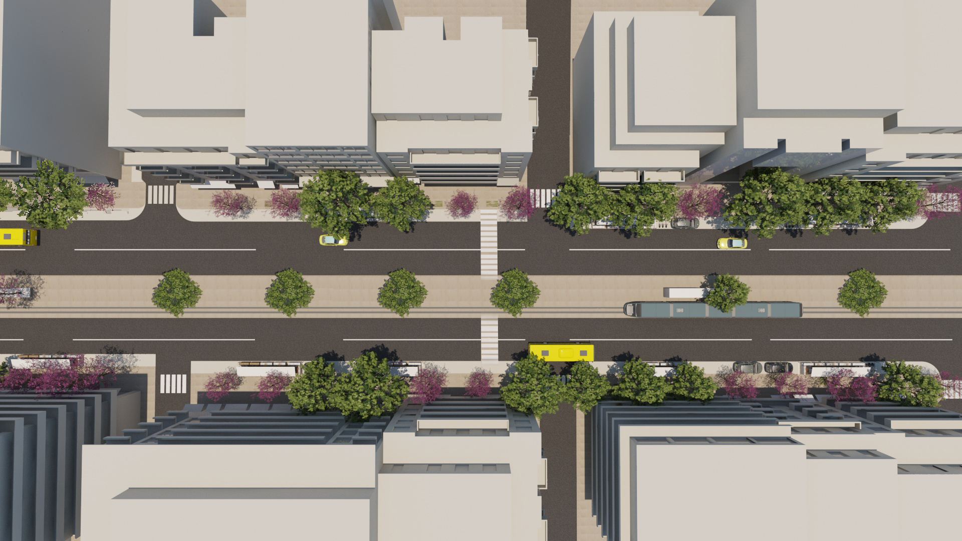
Transportation & Public Space · Athens, Greece
Patision Avenue, Athens
A comprehensive urban regeneration strategy for one of Athens's most congested arterial corridors. The proposal redistributes road space from private cars to public transport, cycling, and pedestrians — reducing traffic speed, adding tree canopy, widening footways, and creating dedicated bus lanes. Shop owners and residents were central to the co-design process throughout.
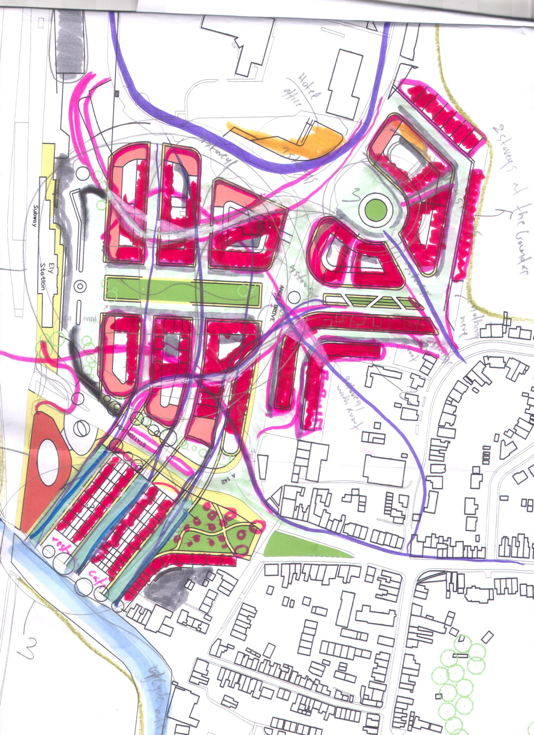
Urban Planning · Ely, United Kingdom
Ely Urban Planning
A strategic gateway area redevelopment proposal for the city of Ely, reconnecting the historic Cathedral precinct with the Great Ouse river corridor and surrounding green areas. The plan restructures movement, introduces mixed-use development, and creates a legible sequence of public spaces from the station arrival to the waterfront.
Urban Planning · Ely, United Kingdom
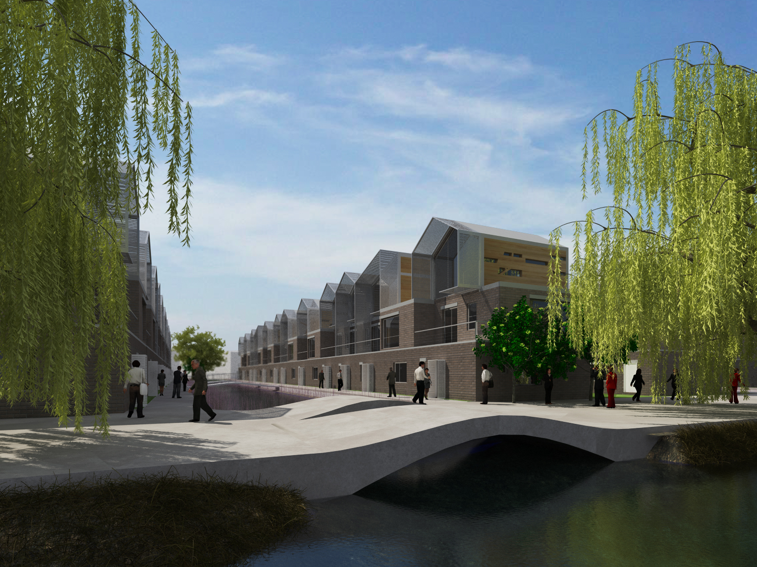
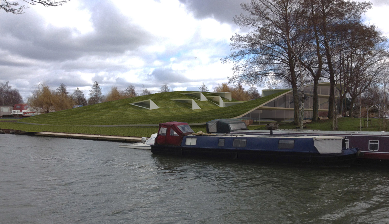
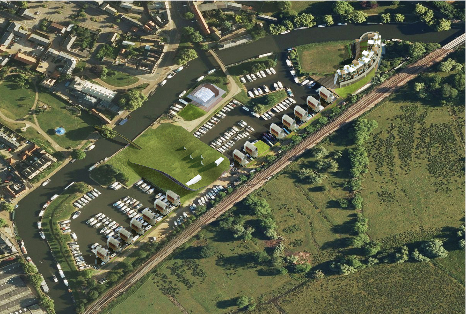
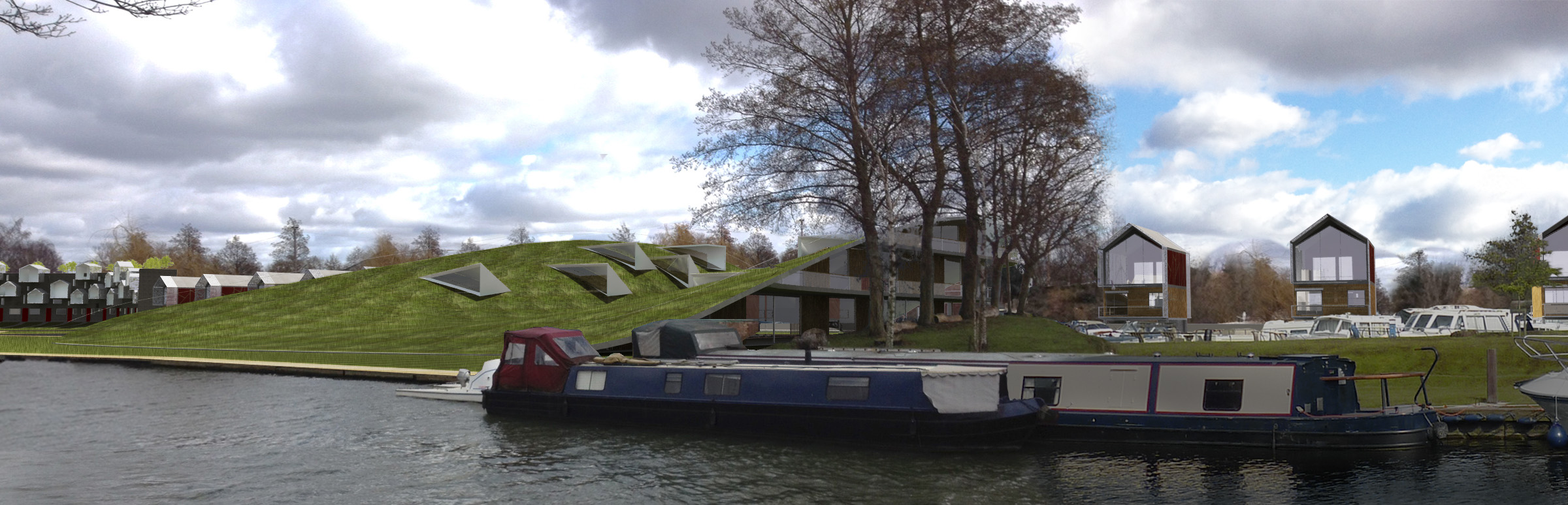
Ely Marina
An urban planning project for Ely's marina district, proposing a mixed-use waterfront development that balances leisure, housing, and ecological restoration along the Great Ouse. The scheme prioritises pedestrian and cycling access, activates the water's edge with public space, and introduces sustainable building typologies suited to the fenland landscape.
Urban Regeneration · Athens, Greece
Glyfada Open Market & Municipal Gardens
An abandoned municipal building in the heart of Glyfada was reimagined as a vibrant open market and community garden. The intervention connects the existing street network, creates new public space, and introduces a sustainable food-production model — transforming an urban void into a civic anchor serving the whole municipality.
Reduce private vehicle throughput by 40% while maintaining access for residents and local businesses
ReducIntroduce dedicated bus rapid transit lanes improving transit reliability and journey times
Plant 200+ street trees to reduce urban heat island effect and improve air quality
Widen footways from 1.5 m to 4–6 m, enabling active street frontage and outdoor use
Create a continuous protected cycling route along the full 4 km corridor
Revitalise ground-floor commercial uses through an improved pedestrian environment
Working with the Community
Reduced car speed to 30 km/h throughout the corridor
Street trees and green buffers separating carriageway from footway
Large sidewalks enabling outdoor dining, markets, and play
Protected bicycle routes fully segregated from motor traffic
Community-engaged design process with 400+ participant workshops
Monthly progress reviews with local business associations